Tuesday, September 27, 2011

Wildfire in Pagami Creek, MN


August 18, 2011,http://www.usatoday.com/weather/wildfires/story/2011-09-14/minnesota-wildfire/50402672/1
Lightening strikes in Boundary Waters Canoe Area Wilderness in NE Minnesota, which ended up starting a 16 mile run forest fire. By Sept 12, 2011 the Incident Information System reported that the creek fire ran a distance of 16 miles, which reached an excess of 60,000 acres. NASA took satellite imagery of the fast expansion of the fire within hours. The photos show the development of the plume. The fire also created it's own weather, it created thunderstorm clouds, bringing more lightening. The fire caused evacuations in the area and more than 100 firefighters battled the fire starting on September 13, 2011. 
http://earthobservatory.nasa.gov/IOTD/view.php?id=52130

Monday, September 26, 2011

Earthquake in the Himalayas

Sept 22, 2011
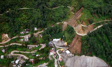
An earthquake occurred in the Himalaya mountains on Sept 18, 2011 located on the outside of Gangtok, India. The article found reports how the earthquake caused mudslides and avalanches that caused a wire bridge to be destroyed and damaged a number of homes. This is a very unstable region that threatens the glacier lakes around the area, such as Imja. There are people working on helping to secure these glacier lakes from the earthquake that possibly destabilized the natural dams holding in these lakes. Created a Mountain Institute Expedition hoping that this expedition will help in the future with dealing with climate hazards such as this situation. Flooding of the glacier lake Imja could cause a major flood destroying up to 100 km of farmland and infrastructure in this relatively poor area. Below is an aerial photo of an earthquake affected area. 
http://www.guardian.co.uk/environment/2011/sep/22/himalayas-earthquake-glacier-lakes
Suzanne in Nepal : Earthquake

Thursday, September 22, 2011

Flooding in the Midwest

The Midwest has been experiencing major flooding this summer that have caused roads, railroad tracks and bridges to close. The picture above taken June 21, 2011, is a flooded road closure in Corning, Missouri, with heavy flooding from the Missouri River. 300 residents were told to evacuate because of two breaches in Missouri River levees. The flooding in Omaha Nebraska has caused volunteers to place 200,000 sandbags  to protect public property from flooding. Further north in Minot, ND, 11,000 people have been told to evacuate or a quarter of the cities residents.
http://www.ibtimes.com/articles/167675/20110622/omaha-missouri-river-fort-calhoun-minot-north-dakota-floods-evacuation-sandbags-souris-river.htm


Below is a video of some footage taken from a car driving along I-29 in Sioux City, Iowa showing some of 
the flooding occurring in the Midwest. This footage was taken 6/18/2011. 
http://www.youtube.com/watch?v=zgWCam9S7JE


This is a video a person shot while driving along I-29 in South from Nebraska towards Missouri of all the flooding that has been occurring this summer it was taken 6/18/2011.
http://www.youtube.com/watch?v=zgWCam9S7JEhttp://www.youtube.com/watch?v=zgWCam9S7JE

Sunday, September 18, 2011

Drought in South Central United States Costing Billions


July 14, 2011
http://www.youtube.com/watch?v=xyfVvAURMpY&feature=related
Sept 15, 2011
Chris Dolce
There has been billions of dollars lost in agriculture in the dry south central parts of the United States. This summer has brought little rain and record breaking hot temperatures and even though rain has come to some parts in the area, it wont be enough to make up for the loss from the drought. Estimates as of Sept 15, 2011 guess that Texas, Kansas, and Oklahoma have lost more than 8 millions dollars combined, and it it expected to continue to increase. In Texas about 88 percent of the state is in exceptional drought, which is the worst category. Some cotton farmers have actually left their fields with the lack of rainfall and some ranchers have had to relocate their herds to adjacent states so as to have lower feeding costs. According to USA Today, Texas has had record-breaking hot temperatures June through August with an average of 86.8 degrees Farenheit, which is the hottest summer for any state in U.S. history. Texas has been estimated to lose $5.2 billion dollars.  In Kansas 2/3 of the state are in moderate to exceptional drought as of September 13, with a loss of about $1.7 billion dollars.  Oklahoma has about 93 percent of the state being in the extreme to exceptional drought category with an estimated loss of $1.6 billion dollars.  Below is a map of Texas' drought category as of Sept 13, 2011.


This is a drought map of Texas as of Sept 13, 2011 with the darkest red shading being exceptional drought, the worst drought category. Image courtesy: NDMC/USDA/NOAA. 
http://www.weather.com/outlook/weather-news/news/articles/drought-south-central-cost_2011-09-15
http://www.usatoday.com/weather/drought/story/2011-09-12/texas-drought-Dust-Bowl-ranchers/50373618/1

Wednesday, September 14, 2011

Tropical Storm Maria Leaving Puerto Rico Heading North

Tropical Storm Maria
http://www.weather.com/weather/hurricanecentral/article/tropical-depression-14-storm-hurricane-maria_2011-09-05
 09/14/2011
Puerto Rico experienced flash flooding with heavy rains coming from tropical storm Maria this past Monday and Tuesday. As Maria pulls away and heads north the rains will weaken and is not scheduled to hit the East Coast of the U.S. On Thursday morning, the center of the storm will pass in between the U.S. and Bermuda. A tropical storm warning has been issued for Bermuda, since the storm has possibilities of causing tropical storm conditions in the area.
The Picture above is of the path Maria is expected to take, where it will be on Thursday and Friday night, and what the expected mph will be. According to the picture it the storm will be around 65 mph by Friday night.
A sweet interactive map that followed the path of the tropical storm Maria. When looking at the hurricane tracker of Maria, it is similar to the picture above, except that it is interactive and has a rotating "storm" that is guided down an interactive path. It also tells you the maximum speeds, pressure and a wind speed chart. It also allows you to zoom in and out too see where the storm is in location to other parts of the world.
http://www.weather.com/weather/hurricanecentral/tracker

Monday, September 12, 2011

Recovery from Tropical Storm Irene in New York

Michael Kirby Smith for the New York Times
Sam Dolnick
August 28, 2011

Many of the streets of New York City, as well as suburbs were flooded in low-lying areas while Tropical Storm Irene, continued to the New England area after the storm that Sunday. The Eastern Seaboard has been left with millions of homes without power where fallen trees have brought down many wires. Even though the storm was down graded from a hurricane to a tropical storm before it hit New York, firefighters in boats rescued more than 60 people from 5 foot flooding on Staten Island and at least 5 storm-related deaths were reported in New York and New Jersey. New York City prepared for the storm by shutting down the mass- transit network, sandbagging Fifth Avenue, and issuing and evacuation of 370,000 people in the city. Even though it was down graded from a hurricane, the storm reached 65 miles per hour winds, causing it to be the largest storm to hit the city in 25 years. A lot of the damage was mainly noticed in the suburbs and adjacent states with the large areas with lost power and flooding. In New Jersey more than 800,000 people were without power, and in Philadelphia had reached flooding levels that have not been seen for 140 years. Despite the smaller amount of damage than was expected, many people were happy with the preparations that were made for a worse case disaster.

http://www.nytimes.com/2011/08/29/nyregion/wind-and-rain-from-hurricane-irene-lash-new-york.html?pagewanted=all

Thursday, September 8, 2011

Forest Fires in Bastrop Texas, Sept 4, 2011


http://www.youtube.com/watch?v=wELdKgk80e8

The Bastrop area in Texas have been experiencing intense wildfires that have been continuing into September and have claimed two lives so far. The fire stretches 34,000 acres and has destroyed 550 homes. Over 4,000 residents in Bastrop have been evacuated. The Texas Forest Service lost about 1/3 of its normal budget last week. They have lost about $35 million over two years. With the very dry conditions in this Bastrop area, it has caused the fires to spread extremely fast. The website also explains what areas are contained and how much is contained at this point. Some residents in the Spicewood area maybe allowed back into their homes. The Federal Emergency Management Agency (FEMA) have aauthorized funds to be used to fight the Texas wildefires.
The website for news on the Texas fires gives updates on the progress of the fires and helpful links such as a link with a list of things to bring when evacuating and ways you can help fire victims.

http://kutnews.org/post/central-texas-wildfire-updates-september-6-2011