Tuesday, December 13, 2011
December 11, 2011
This is a video clip explaining briefly about the earthquake that occurred in Mexico's western Guerrero state. The earthquake had a magnitude of 6.5 and has killed at least three people.
http://www.usatoday.com/news/world/story/2011-12-10/mexico-earthquake/51788440/1
December 11, 2011
On December 10, 2011 a 6.5 magnitude earthquake hit Guerrero state in western Mexico that caused buildings to shake and panic among people in the area. The shaking could be felt in the resort area of Acapulco and at least 3 people have died due to the quake. The quake occurred at a depth of 40.3 miles and was centered 26 miles of the city of Iguala and 103 miles southwest of Mexico City. The quake was felt in parts of nine states in Mexico according to Mexico's Interior Department. Of the three deaths, one man was killed in his house when the roof collapsed, another died in a small town of Ixcateopan and another was killed in a cargo truck by rocks that fell on the vehicle during the quake. Some secondary highways between Acapulco and Mexico City were blocked due to rockslides. There was reportedly not significant damage and power only failed in some areas. Effects of the earthquake were magnified in parts of Mexico City due to the resting of the city on soil of a former lake bed.
http://www.usatoday.com/news/world/story/2011-12-10/mexico-earthquake/51788440/1
Sunday, December 11, 2011
Flooding in Southern Pakistan
September 12, 2011
This is a video describing the flooding that occurred in Pakistan this summer due to the heavy monsoon rains. Many people were stranded and had no food or shelter following the flooding.
http://www.youtube.com/watch?v=L1rs_lciOUI
September 12, 2011
Heavy monsoon rains hit the southern portion of Pakistan killing at least 200 people and 5 million people have become displaced. The country was hit with a devastating flood last year that they are still trying to recover from that killed 1,700 people and displaced 20 million people. The government set up 4,000 medical camps and had provided refuge for 150,000 residents. The floods hit some of Pakistan's areas of high poverty and the government is already trying to manage the country's finances, militant violence and the political upheaval. 21 districts have been affected by the flooding and it spread over 4.1 million acres of land destroying 1.7 million acres of agricultural land. There is also the challenge of the spread of disease since it can be spread easily by the dead farm animals rotting in the sitting flood water.
http://www.globalpost.com/dispatch/news/regions/asia-pacific/pakistan/110912/floods-devastate-southern-pakistan
Tuesday, December 6, 2011
Landslide in Indonesia

December 1, 2011
This is a photo of some of the wreckage from the landslide on Nias Island in Indonesia
http://www.thejakartaglobe.com/news/five-dead-30-missing-in-indonesia-landslide/482011
December 1, 2011
A landslide occurred this past thursday on Indonesia's Nias island killing 5 people and 30 are currently missing. Three days of heavy rains has triggered the landslide burying 37 houses in the 115 family village. It is difficult for the rescuers to reach the island due to the bridge linking the village collapsing. The water currents were also very strong, and it had continued to rain. This area and this island in particular are very prone to natural disasters in that it was not a complete shock that an event like this had happened. In 2004 the island experienced a tsunami that killed more than 300 people and displaced 10,000 people from their homes. The island was also hit in 2005 by an earthquake where 1,500 people had died. So far 5 dead bodies have been pulled out from the mud flow by locals, and there is a continued search for the remaining 30 missing people.
http://www.thejakartaglobe.com/news/five-dead-30-missing-in-indonesia-landslide/482011
Friday, December 2, 2011
Dangerous Wildfires in Nevada
November 18, 2011
This is raw footage of the wildfires that occurred in Reno, Nevada on November 18, 2011
http://www.youtube.com/watch?v=7sv57eaqgno
According to the NOAA Satellite and Information Service one of the worst fires in Nevada's history broke out in southwest Reno on November 18, 2011. The fires were fanned by winds that reached up to 70mph, with flames up to 100 feet high. These wildfires forced almost 10,000 people to evacuate their homes and has destroyed 32 houses and has killed 1. The fires were finally extiniguished by the 20th of November after a total of 1,953 acres were burned in the area. To extinguish the fire was difficult due to the high winds occurring, the rocky terrain, and accessibility to the area.
http://www.ncdc.noaa.gov/sotc/hazards/
Thursday, December 1, 2011
2000 People Stranded in flooding in Australia
November 27, 2011
This is a video with Australia new stories, watching the first minute of the video explains briefly the flooding that is occurring in Australia.
http://www.youtube.com/watch?v=2NyZejibTW8
Floodwaters caused by heavy rain has cut off roads and power isolating more than 2000 people in Australia's New South Wales. More than 900 people have called for emergency help and 29 people have needed to be rescued from the flooding. So far it is known that a 3 year old boy has died after being swept away into a storm-water drain. The town of Wee Waa in northern New South Wales has been temporarily cut off for up to one week by the flooding after the water reached a depth of 7 meters in certain areas and many rivers burst their banks due to the heavy rains. The town with 1,800 people will only be accessible by boat and helicopter and authorities are doing what they can to replenish food supplies. Evacuations have been made in Moree where it is expected that 60 homes will be cut off and already some 150 rural homes in the area have been isolated. The village of Garah near Moree was totally surrounded by water after a levy broke from the heavy rains.
http://www.telegraph.co.uk/news/worldnews/australiaandthepacific/australia/8918567/Two-thousand-people-stranded-by-Australian-floods.html
Wednesday, November 23, 2011
Out of Control Bushfires Rage through an Australian Town
February 7, 2011
This is a news story on the bushfires that hit Australia located in and near Perth in southwestern Australia in February 2011 and the extent of the damage that these fires can cause.
November 24, 2011
Bushfires have been damaging and destroying properties in southwestern Australia in late November 2001. A raging fire swept through an Australian town destroying their homes and forcing residents to evacuate. More than 100 firefighters have been trying to stop the fire which has so far destroyed 20 homes and 750 hectares of bushland in the coastal town of Prevelly, Australia. The fires began with a controlled burn in Leeuwin-Naturaliste National Park which soon became out of control. The blaze became unpredictable and began traveling towards residential areas going 200 meters an hour and there have been speculations as to why they would start a fire when winds had been blowing very hard that day and could easily get out of control. 50 residents in the near by Kilcarnup area were also evacuated and were sent to a popular tourist town incase the fires headed their direction. Firefighters are hoping to be able to control the fires once the wind dies down, right now it is difficult with the great amount of wind that has been occurring. The fires became out of control not only because of the heavy winds, but the temperatures around the state rose and even the Fire and Emergency Services Authority warned that western Australia was facing its most dangerous bushfire seasons in recent history. Bushfires are a regular occurrence in Australia with 64 homes being destroyed in February due to bushfires and the major fires that raged in 2009 named "Black Saturday" killing 65 people, but they are hoping that this current bushfire is able to get under control soon so as no more homes are damaged to the same extent as the February fires.
http://au.news.yahoo.com/thewest/a/-/world/11964469/raging-bushfire-sweeps-through-australian-town/
Friday, November 18, 2011
Largest Eruption for Africa's Nyamuragira Volcano this Century
November 16, 2011
http://www.youtube.com/watch?v=ZZeDUnC8gjg
This is a video reporting on the eruption of Africa's Democratic Republic of Congo's Nyamuragira volcano. Scientists believe that it is the volcanoes largest eruption to happen in a century.
Africa's most active volcano Nyamuragira located in Democratic Republic of Congo began erupting on Sunday night. The volcano is located about 25 miles north of the town of Goma and is located where there is a critically endangered population of mountain gorillas. The volcano erupted 27 times since 1938 and this eruption was one of the largest for the volcano to happen this century. Scientists monitoring the volcanic activity say that the surrounding population located in Goma, the gorillas and the wildlife does not appear to be in danger at this time, so no evacuations have been made. The eruptions have been described as an amazing fire show and tourist treks to the mountain are continuing as usual.
http://www.globalpost.com/dispatch/news/regions/africa/111108/drc-congo-nyamuragira-volcano-erupts-virunga-mountain-gorillas
Sunday, November 13, 2011
Powerful Storm Hits West Coast of Alaska
Video with raw footage of the Alaskan super storm to hit the west coast on November 9, 2011.
November 9, 2011
http://www.youtube.com/watch?v=p6SbZrp8b3k
November 9, 2011
In nearly 40 years a powerful storm with snow and hurricane-force winds hits western Alaska on Wednesday November 9th battering coastal communities and forcing residents to evacuate to higher ground as power has been knocked out and roofs have been ripped up. As the storm was approaching residents and emergency responders braced themselves for possible sea water surges into the coastal communities. Water has already reached four Native villages including Tununak and Kipnuk. So far no reports of injuries, and damages are mainly windows blown out and torn up roofs along with scattered power outages. Highest wind gust recorded for this storm was 85 mph hitting Wales at the western tip of the Seward Peninsula. The community of Nome with one of the biggest coastal communities of about 3,600 people had wind gusts of about 61 mph and power outages for several hours. Residents along Front Street located less than 100 feet form the seawall protecting the town from the Bering Sea were asked to evacuate to higher ground for a night prior to the storm hitting.
http://www.cbsnews.com/8301-505245_162-57321706/powerful-storm-batters-alaskas-western-coast/
Sunday, November 6, 2011
Thailand Flood Killing 506 People and the Rising Waters in Bangkok
October 4, 2011
This is a video from a month earlier explaining the situation of the post flood measures and the threatening of the flooding to reach the center capital city of Bangkok
November, 6, 2011
The current flooding in Thailand has been the worst in a half a century with the death toll continuing to rise and reaching past 500 deaths and counting. New evacuation have been ordered in the city of Bangkok as polluted black water is continuing to flow into the city and threatening the subway system. So far there have been 11 of Bangkok's 50 districts with evacuations ordered along with partial evacuations in 7 more districts. The evacuations are not mandatory so most people are staying to protect their homes and businesses, but the orders show how the flooding is continuing to progress and the government is having troubled controlling the situation. Rainfall has been drenching Thailand since late July killing 506 people most being killed by drowning, but a handful have been killed by flood related electrocutions as well. A few days earlier workers finished a 3.7 mile flood wall made from large sandbags to try and divert some of the water that is flowing towards central Bangkok, but a large amount of the water is already past the wall and continuing to push towards the center of the city. Prime Minister Yingluck Shinawatra says that there is a plan that would allocate $3.3 billion dollars for post-flood reconstruction.
http://abcnews.go.com/International/wireStory/death-toll-thailand-floods-rises-past-500-14890736#.TrcNnVYUkZQ
Wednesday, November 2, 2011
Hudson Volcano Releasing Ash Clouds has Chile and Argentina on Alert
http://www.youtube.com/watch?v=M3L5QN28fh4
October 27, 2011
This is a video describing the warning of the possibility of a major eruption to occur at the Hudson Volcano located in southern Chile and how people have been evacuated.
October 28, 2011
The Hudson volcano located in southern Chile in Patagonia has released 3 large columns of steam and ash that have formed into a cloud more than 3 miles high. This has authorities in Chile and Argentina on alert for the possibility of a much larger eruption to occur. The Hudson volcano has erupted 2 times in the past 60 years and the most recent in 1991 piled up 18 inches of ash and killed an estimated 1.5 million sheep on the Argentine side of the Andean mountains. 119 people have been evacuated from the immediate area and people nearby are prepared to flee with the melting of the snow and ice causing the Aysen river to overflow onto its banks since the volcano is covered by a glacier. If a major eruption were to occur then prevailing winds could possibly blow the ash across the continent of South America, cutting off supply routes and air travel to the southern area of Argentina. The steam and ash are erupting from three craters ranging from 650 feet to 1,600 feet wide and with earthquakes causing a shaking of the mountain, a major eruption could happen within days not to mention a plume of ash and steam have already spread 7.5 miles toward Argentina. It is good that there has been an evacuation of people and that authorities are aware that a possible major disaster could occur if the volcano was to erupt again with more force.
http://www.seattlepi.com/news/article/Ash-cloud-rises-above-restive-Chilean-volcano-2240851.php#photo-1706062
Tuesday, November 1, 2011
Damaged Reactors at Japanese Nuclear Plant Could Take 30 Years to Retire
http://www.youtube.com/watch?v=Y67S54Q0QBk&feature=related
Above is a video from MSNBC reporting in March on the explosions at the Fukushima nuclear power plant and the beginnings of the distribution of radiation in the area. The article below reports on the progress or the continuation of the issues with the nuclear power plant.
November 1, 2011,
After the March 11, 2011 earthquake and tsunami that hit Japan and damaged the Fukushima Daiichi nuclear power plant along the coast, it is estimated that the decommissioning or four reactors will likely take more than 30 years to complete. Japanese officials report that the decommissioning at Fukushima is complicated and the goal to start taking out debris and finish decommissioning within a 10 year period is estimated to extend to 30 years. Temperatures in the three reactors of the nuclear plant since the disaster have been brought down to 100 degrees Celsius, but the company needs to maintain the conditions for a while before the reactors are declared to be in cold shutdown and then debris will be able to be removed. The removal of fuel at the plant is expected to take years as well because the extent of the damage was very severe. It is expected to take years to clean up the worst nuclear disasters since Chernobyl since hydrogen explosions blew apart the No.1 and No.3 reactor housings, the No. 2 reactor is also suspected to have experienced a hydrogen blast and the No. 4 reactor housing experienced damage from fires caused by heat of the fuel. Volunteers collecting data around Japan have found that a significant amount of radiation has contaminated the water and released into the Pacific Ocean and it will take a lot of time for the contamination to be dispersed and diluted. Radioactive particles from the nuclear plant has displaced around 80,000 people living within 20 kilometer radius of the plant along with residents of a village about 40 kilometers northwest of the plant.
http://www.cnn.com/2011/11/01/world/asia/japan-nuclear/index.html?hpt=wo_c2
Monday, October 31, 2011
Heavy Snow in Northeastern United States Leaves 3 Million without Power
A news story video of the snowstorm to Northeastern United States.
http://www.youtube.com/watch?v=TM9appCOQTg
October, 30, 2011
A freak snowstorm in October hits northeastern U.S. leaving more than 3.2 million homes and businesses without power with 60 centimeters falling in some areas over the weekend. The storm caused major damage because many of the leaves are still on the trees thus catching a lot of the heavy and wet snow causing branches and trees to snap from the weight. The storm has also been blamed for the death of 11 people along with the shut down of roads, railways, and airline flights. The storm extended from Maine to Maryland and it is claimed that to restore the electricity could take several days. The storm broke record snowfall totals in October and it became even worse as it moved more north having communities in western Massachusetts being hit the worse. This type of storm isn't typical at this time of year in the are but an area of high pressure over southeastern Canada funneled cold air south into the U.S. and the cold air combined with the moisture coming from the North Carolina coast producing the devastating snow storm.
http://www.thestar.com/article/1078425--early-storm-deals-u-s-northeast-wet-heavy-snow-leaves-3-million-without-power-kills-9
Tuesday, October 25, 2011
Flood in Thailand Threatening Village with Dike Breakage
http://www.cnn.com/2011/10/25/world/asia/thailand-flood/index.html?hpt=wo_c2
October 25, 2011
Early Tuesday morning residents of Munag Ake village in Thailand are urged to evacuate the area due to parts of a dike located in Tambon Lak Hok, Muang District in the Pathum Thani province has broken and it is expected that a large amount of water will flow though the village. It's estimated that flood waters could reach about 5 feet. Prime Minister Yingluck Shinawatra has urged employers for the private and public sectors to allow time off for staff in affected areas. Flights have also been canceled in Bangkok's Don Muang airport due to flood waters reaching the airport. Government says that the flooding is the worst in the country in half a century and certain areas could require more than a month before the waters recede. Already 356 people have been killed by the flooding and about 9 million other people have been affected by it. This coming week more high tides are expected to cause river back up and more floodings. As of now the government has set up 1,700 shelters in the country and over 113, 000 people have taken refuge at these places. So far damages from the flooding is expected to cost up to $6 billion dollars, but this is predicted to rise and Thailand's important part of income, the tourism has been greatly affected by the disaster.
Sunday, October 23, 2011
Rising Death Toll in Turkey Earthquake
http://www.youtube.com/watch?v=cHCASnI0eig
This is a video reported on CNN about the earthquake that occurred in Turkey.
10/24/2011
An earthquake with a magnitude of 7.2 occurred in Turkey on Sunday injuring 350 people and killing at least 217 people. This has been the most powerful earthquake in more than a decade in to occur in the country. About 20 aftershocks occurred in eastern Turkey in one of Turkey's poorest areas with the largest magnitude being 6.0. Rescue workers and residents in eastern Turkey are battling near freezing temperatures and darkness trying to go through the wreckage and search for survivors. The prime minister estimates that death toll is going to continue to rise as the rescuers are continuing to search for people trapped in the rubble.
http://edition.cnn.com/2011/10/23/world/europe/turkey-earthquake/index.html?hpt=hp_t1
Monday, October 17, 2011
Extreme Fire Threat for New Mexico and West Texas
http://www.youtube.com/watch?v=m67ZokFYl2A
Sept 6, 2011
This is a raw video from the Texas Parks and Wildlife on the wildfires burning up Bastrop State Park, two-thirds of the 6,000 acre park have burned up already
October 17, 2011
Strong winds, warmth and low humidity are all combining early this ween creating an extreme fire threat from parts of New Mexico and West parts of Texas. A cold front in the High Plains will bring wind gusts of 40-50 mph to this area and any fires already in existence and new fires will fan out from winds of this magnitude. In places such as Lubbock, Texas, new record high temperatures could be set. High temperatures are set to climb 15 degrees above the normal temperatures in areas ahead of the cold front. with the very dry air, the relative humidity levels will drop below 20%, which doesn't help the already the bad drought conditions across Texas and the plenty of tinder dry grass and brush to help fuel the fires.
http://www.accuweather.com/blogs/news/story/56442/extreme-fire-threat-grips-new-1.asp
Sunday, October 16, 2011
New Zealand Crews Pump Oil from Ship Leaking Oil
http://www.youtube.com/watch?v=PW-tZKTX89Q
This is a video from the associated press about the oil spill that occurred off of the coast of New Zealand
October 14, 2011
It is estimated that 300 tons of heavy fuel oil has spilled from a cargo ship named Rena with a cracked hull off of the coast of New Zealand. The week before 10 tons were drained from the ship but bad weather forced a temporary suspension of the operation. Salvage are now looking to return to pump the remaining fuel and have installed equipment and platforms to provide a level base for the operation. Environmentalists are worried that there will be a major disaster for the wildlife if all 1,700 tons of oil and 200 tons of diesel spill into the ocean. An estimated 1,000 people including soldiers, wildlife experts and residents have come to help and in total it is estimated that some 3,000 people have volunteered to help. So far some 1,000 birds have died since the accident.
http://www.bbc.co.uk/news/world-asia-pacific-15305816
Thursday, October 13, 2011
Many Malnourished Children in North Korea due to Flooding
http://www.youtube.com/watch?v=VtypFK9Nap8
October 6, 2011
Above is a video of the issue of malnourishment of children in North Korea. The Reuters AlertNet humanitarian news service shot the video in South Hwanghae, a farming province in the country's heartland. This malnourishment is due to the major flooding and harsh winter that has occurred. The failed harvests have led to major food shortages in the country. The World Food Program has was that it only has 30% of the funding needed for relief to reach the 3.5 million of North Korea's most vulnerable people. It was estimated in March that a quarter of the countries 24 million inhabitants needed food aid and that one third of all the children were chronically malnourished. Seoul has abandoned their offer to provide emergency flood aid this week claiming that Pyongyang (the area affected) has not responded. There is some suspicion that Pyongyang could be hoarding crops to make sure there is enough food next year. The governing People's Committee has said that the harsh winter destroyed 65% of South Hwanghae's barley, wheat and potato crops. 80% of the maize harvest has been destroyed by flooding and typhoons.
http://www.guardian.co.uk/world/2011/oct/06/north-korea-malnourished-ophans-floods
Tuesday, October 4, 2011
Lab 4: Flooding in Cambodia Worst in 11 years
Cambodia has been experiencing flash floods since August with the occurrance of heavy rains and the flooding of the Mekong River, at least 150 people have been killed, worst since 2000 when 374 people were killed. Several dykes have broken along the Mekong River allowing for major flooding in the area on top of the already great amount of rain fall.
Engineering approach: A link looking at a meteorlogical map showing the amount of current precipitation based of of 24 hour precipitation totals in areas around the world could give an engineering approach for flooding using scientific weather forcasting. Looking at the current meteorlogical map of Cambodia, it is seen that there is still some precipitation in the area months after the significant amount of flooding and rainfall that has been occurring since August. The rainfall is measured using rain gauges placed to uniform height, measuring with up to an accuracy of 0.1mm or 0.01in.
http://www.intellicast.com/Global/Precipitation/Current.aspx
Another good link is the GDACS- the Global Flood Detection System which gives current information on flooding worldwide showing the areas affected by flooding. By selecting Cambodia as an area I can see the areas affected by flooding. There are also links on the side with information about the current flooding that is occurring.
http://www.gdacs.org/flooddetection/searchareas.aspx
Behavioural Approach: In a disaster such as a flood it is important to evacuate people quickly and make sure people at least have a short term warning and know about what is going to happen. Allowing for a system to get message across about a natural disaster that will be occurring will help with a better long term plan of avoiding areas prone to floods and gives a warning for it. HEWS or Humantitarian Early Warning Service gives a flooding monitoring page of floods going on more recently as well as in the past, listed by the date the flood has occurred. By clicking on a specific flood, it shows the start date, cause of storm and the estimated population within 60 km. This would be a good website to look at and see where floods are occurring to be able to stay away from certain sites, but since Cambodia is not a developed country it most likely does not have access to websites such as these to monitor floods in thier area.
http://hewsweb.org/floods/#
The Global Disaster Alert and Coordinate System gives a good analysis of the impact of the Cambodian flooding, as well as helpful maps that could help to understand the contributions of why the impact was so great. It has a population density map, which shows that the great amount of the populations are along the rivers, one in particular being the Mekong River which flooded greatly.
http://www.gdacs.org/reports.asp?eventType=FL&ID=2011_3853&country=Cambodia&location=0&system=asgard&alertlevel=Orange&glide_no=0
Developmental Approach: Cambodia is a fairly poor country that has suffered greatly in disasters, such as flooding because they don't have enough sophisticated equipment and techniques to help prepare the people that are living here from flooding disasters. This makes them more vulnerable to disaster and the impacts are great. Cambodia has been suffering the worst from the Mekong flash floods in the last decade this most recent one has killed 150 people, destroyed 130,220 homes, affected 270,000 hectares of rice paddies, which is important economically. By not having the most accurate equipment, structures and protection from a flooding disasters, the impacts are heightened.
http://news.xinhuanet.com/english2010/world/2011-10/03/c_131172904.htm
http://www.youtube.com/watch?v=fkdxUwUxJNQ
This video is of the flooding occurring in Siem Reap, Cambodia in September 2011 a month after heavy rainfall has been occurring since August. From the video footage it shows that the flooding is still pretty significant and also with the conditions of the town you can see it is not as developed of a country as say the United States.
Complexity Approach: Looking at all the different interactions that could have caused the impact of the flooding in a poor country, such as Cambodia, there isn't much surprise that the flooding impacted them greatly. With the country not having a great amount of sophisticated equipment and techniques, it would be hard for local people to be able to monitor flooding in thier areas and be able to be more prepared for them. Also since the economy is pretty poor here, they won't have the most up to date structure that would help with an oncomng flood and protect important buildings. With the lack of equipment and technologies, it would be hard make and organize warnings and evacuations for the area. The poorest of people located most likley on the areas most prone to flooding, would not have a warning to know to leave the area because a disaster is going to occur. The economy has played a major role in the impact of Cambodia and the floodign that has been going on since August. With the poor economy it is hard to put money towars long term planning for situations such as these and they still remain very vulnerable to disasters The relief for the flood victims in these poor areas need to go into effect so that it is known globally and a plan of action can occur. Currently Plan International is distributing relief kits to over a 1,000 familes affected. Plan Cambodia is working with the government to help with disaster management in the future. Overall there are many interactions that have helped to contribute to the outcome of the flooding and these were just some of the one's considered.
http://www.trust.org/alertnet/news/plan-provides-relief-to-flood-hit-families-in-cambodia
Sunday, October 2, 2011
59 Killed in Philippines in Back to Back Typhoons

10/2/2011
Typhoon Nalgae slammed onto the northeastern province of Isabela in the Philippines October 1, 2011. It also came across the main island of Luzon leaving at least three people dead. This is one day after Typhoon Nesat killed 56 other people and left 28 missing in the same region. A day after Typhoon Nalgae rescuers delivered food and water to hundreds of people stuck on rooftops for days because of the flooding from the typhoons. Nalgae had winds up to 75 miles per hour with gusts of 93 mph. After the typhoons China's National Meteorological Center urges people in expected areas to be hit by the storms in the next 3 days on southern part of Hainan island and eastern Taiwan to stay indoors and cancel big assemblies. Nalgae caused a rock slide in northern mountain province of Bontoc in the Philippines, which killed one person in a van who was pinned to death from boulders coming down the mountain. Once Nesat was downgraded to a tropical storm, it headed towards Vietnam on Friday causing 20,000 people to be evacuated. President Benigno Aquino III ordered authorities to study how villagers and fisherman can be forced to follow storm warnings to help prevent future casualties. Damage on agriculture and infrastructure from the typhoons in the Philippines estimated $200 million dollars.
Typhoon Nalgae slammed onto the northeastern province of Isabela in the Philippines October 1, 2011. It also came across the main island of Luzon leaving at least three people dead. This is one day after Typhoon Nesat killed 56 other people and left 28 missing in the same region. A day after Typhoon Nalgae rescuers delivered food and water to hundreds of people stuck on rooftops for days because of the flooding from the typhoons. Nalgae had winds up to 75 miles per hour with gusts of 93 mph. After the typhoons China's National Meteorological Center urges people in expected areas to be hit by the storms in the next 3 days on southern part of Hainan island and eastern Taiwan to stay indoors and cancel big assemblies. Nalgae caused a rock slide in northern mountain province of Bontoc in the Philippines, which killed one person in a van who was pinned to death from boulders coming down the mountain. Once Nesat was downgraded to a tropical storm, it headed towards Vietnam on Friday causing 20,000 people to be evacuated. President Benigno Aquino III ordered authorities to study how villagers and fisherman can be forced to follow storm warnings to help prevent future casualties. Damage on agriculture and infrastructure from the typhoons in the Philippines estimated $200 million dollars.
Tuesday, September 27, 2011
Wildfire in Pagami Creek, MN

August 18, 2011,http://www.usatoday.com/weather/wildfires/story/2011-09-14/minnesota-wildfire/50402672/1
http://earthobservatory.nasa.gov/IOTD/view.php?id=52130
Monday, September 26, 2011
Earthquake in the Himalayas
Sept 22, 2011
An earthquake occurred in the Himalaya mountains on Sept 18, 2011 located on the outside of Gangtok, India. The article found reports how the earthquake caused mudslides and avalanches that caused a wire bridge to be destroyed and damaged a number of homes. This is a very unstable region that threatens the glacier lakes around the area, such as Imja. There are people working on helping to secure these glacier lakes from the earthquake that possibly destabilized the natural dams holding in these lakes. Created a Mountain Institute Expedition hoping that this expedition will help in the future with dealing with climate hazards such as this situation. Flooding of the glacier lake Imja could cause a major flood destroying up to 100 km of farmland and infrastructure in this relatively poor area. Below is an aerial photo of an earthquake affected area.
http://www.guardian.co.uk/environment/2011/sep/22/himalayas-earthquake-glacier-lakes
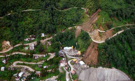
Thursday, September 22, 2011
Flooding in the Midwest
The Midwest has been experiencing major flooding this summer that have caused roads, railroad tracks and bridges to close. The picture above taken June 21, 2011, is a flooded road closure in Corning, Missouri, with heavy flooding from the Missouri River. 300 residents were told to evacuate because of two breaches in Missouri River levees. The flooding in Omaha Nebraska has caused volunteers to place 200,000 sandbags to protect public property from flooding. Further north in Minot, ND, 11,000 people have been told to evacuate or a quarter of the cities residents.
http://www.ibtimes.com/articles/167675/20110622/omaha-missouri-river-fort-calhoun-minot-north-dakota-floods-evacuation-sandbags-souris-river.htm
This is a video a person shot while driving along I-29 in South from Nebraska towards Missouri of all the flooding that has been occurring this summer it was taken 6/18/2011.
http://www.youtube.com/watch?v=zgWCam9S7JEhttp://www.youtube.com/watch?v=zgWCam9S7JE
Sunday, September 18, 2011
Drought in South Central United States Costing Billions
July 14, 2011
http://www.youtube.com/watch?v=xyfVvAURMpY&feature=related
Sept 15, 2011
Chris Dolce
There has been billions of dollars lost in agriculture in the dry south central parts of the United States. This summer has brought little rain and record breaking hot temperatures and even though rain has come to some parts in the area, it wont be enough to make up for the loss from the drought. Estimates as of Sept 15, 2011 guess that Texas, Kansas, and Oklahoma have lost more than 8 millions dollars combined, and it it expected to continue to increase. In Texas about 88 percent of the state is in exceptional drought, which is the worst category. Some cotton farmers have actually left their fields with the lack of rainfall and some ranchers have had to relocate their herds to adjacent states so as to have lower feeding costs. According to USA Today, Texas has had record-breaking hot temperatures June through August with an average of 86.8 degrees Farenheit, which is the hottest summer for any state in U.S. history. Texas has been estimated to lose $5.2 billion dollars. In Kansas 2/3 of the state are in moderate to exceptional drought as of September 13, with a loss of about $1.7 billion dollars. Oklahoma has about 93 percent of the state being in the extreme to exceptional drought category with an estimated loss of $1.6 billion dollars. Below is a map of Texas' drought category as of Sept 13, 2011.

This is a drought map of Texas as of Sept 13, 2011 with the darkest red shading being exceptional drought, the worst drought category. Image courtesy: NDMC/USDA/NOAA.
http://www.weather.com/outlook/weather-news/news/articles/drought-south-central-cost_2011-09-15
http://www.usatoday.com/weather/drought/story/2011-09-12/texas-drought-Dust-Bowl-ranchers/50373618/1
Wednesday, September 14, 2011
Tropical Storm Maria Leaving Puerto Rico Heading North

http://www.weather.com/weather/hurricanecentral/article/tropical-depression-14-storm-hurricane-maria_2011-09-05
09/14/2011
Puerto Rico experienced flash flooding with heavy rains coming from tropical storm Maria this past Monday and Tuesday. As Maria pulls away and heads north the rains will weaken and is not scheduled to hit the East Coast of the U.S. On Thursday morning, the center of the storm will pass in between the U.S. and Bermuda. A tropical storm warning has been issued for Bermuda, since the storm has possibilities of causing tropical storm conditions in the area.
The Picture above is of the path Maria is expected to take, where it will be on Thursday and Friday night, and what the expected mph will be. According to the picture it the storm will be around 65 mph by Friday night.
A sweet interactive map that followed the path of the tropical storm Maria. When looking at the hurricane tracker of Maria, it is similar to the picture above, except that it is interactive and has a rotating "storm" that is guided down an interactive path. It also tells you the maximum speeds, pressure and a wind speed chart. It also allows you to zoom in and out too see where the storm is in location to other parts of the world.
http://www.weather.com/weather/hurricanecentral/tracker
Monday, September 12, 2011
Recovery from Tropical Storm Irene in New York

Michael Kirby Smith for the New York Times
Sam Dolnick
August 28, 2011
August 28, 2011
Many of the streets of New York City, as well as suburbs were flooded in low-lying areas while Tropical Storm Irene, continued to the New England area after the storm that Sunday. The Eastern Seaboard has been left with millions of homes without power where fallen trees have brought down many wires. Even though the storm was down graded from a hurricane to a tropical storm before it hit New York, firefighters in boats rescued more than 60 people from 5 foot flooding on Staten Island and at least 5 storm-related deaths were reported in New York and New Jersey. New York City prepared for the storm by shutting down the mass- transit network, sandbagging Fifth Avenue, and issuing and evacuation of 370,000 people in the city. Even though it was down graded from a hurricane, the storm reached 65 miles per hour winds, causing it to be the largest storm to hit the city in 25 years. A lot of the damage was mainly noticed in the suburbs and adjacent states with the large areas with lost power and flooding. In New Jersey more than 800,000 people were without power, and in Philadelphia had reached flooding levels that have not been seen for 140 years. Despite the smaller amount of damage than was expected, many people were happy with the preparations that were made for a worse case disaster.
http://www.nytimes.com/2011/08/29/nyregion/wind-and-rain-from-hurricane-irene-lash-new-york.html?pagewanted=all
Thursday, September 8, 2011
Forest Fires in Bastrop Texas, Sept 4, 2011
http://www.youtube.com/watch?v=wELdKgk80e8
The Bastrop area in Texas have been experiencing intense wildfires that have been continuing into September and have claimed two lives so far. The fire stretches 34,000 acres and has destroyed 550 homes. Over 4,000 residents in Bastrop have been evacuated. The Texas Forest Service lost about 1/3 of its normal budget last week. They have lost about $35 million over two years. With the very dry conditions in this Bastrop area, it has caused the fires to spread extremely fast. The website also explains what areas are contained and how much is contained at this point. Some residents in the Spicewood area maybe allowed back into their homes. The Federal Emergency Management Agency (FEMA) have aauthorized funds to be used to fight the Texas wildefires.
The website for news on the Texas fires gives updates on the progress of the fires and helpful links such as a link with a list of things to bring when evacuating and ways you can help fire victims.
http://kutnews.org/post/central-texas-wildfire-updates-september-6-2011
Subscribe to:
Posts (Atom)